Potato Chip Rock: The Mount Woodson Hike and How to Do It
Potato Chip Rock is the thin granite ledge on Mount Woodson that has become one of the most photographed spots in San Diego County. Here is how the hike works, which side of the mountain to start from, and how to fit it into a wider trip.

Short answer
Potato Chip Rock is a wafer-thin granite slab near the top of Mount Woodson, east of Poway, reached on foot from either the Lake Poway side or the Mount Woodson trailhead off Highway 67. The hike is a steady, exposed climb with almost no shade, so most people start at or before sunrise, and the photo line at the rock itself can run long on weekends.
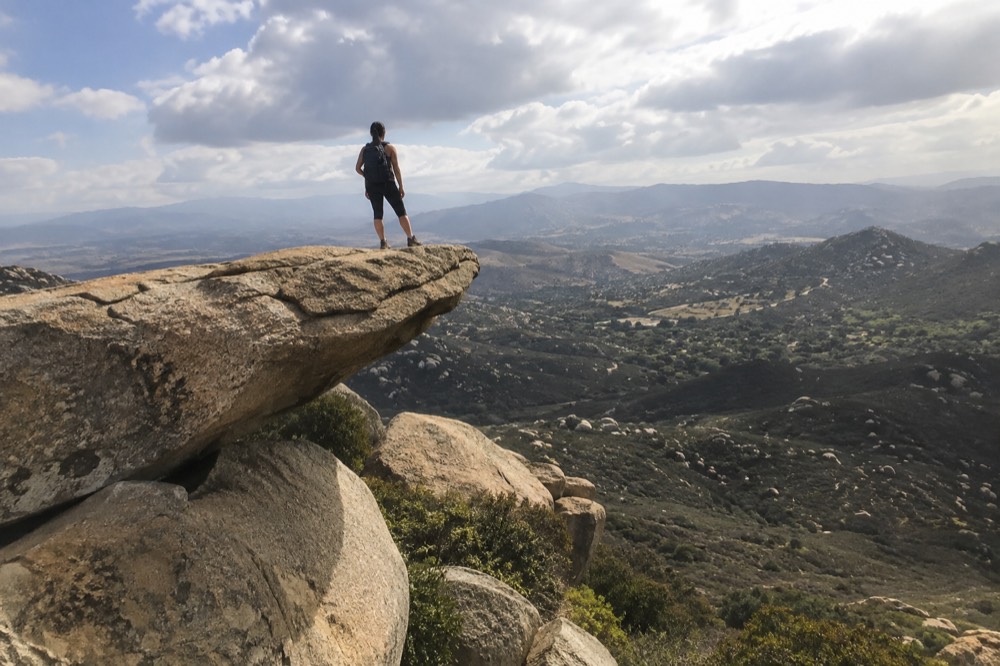
What Is Potato Chip Rock?
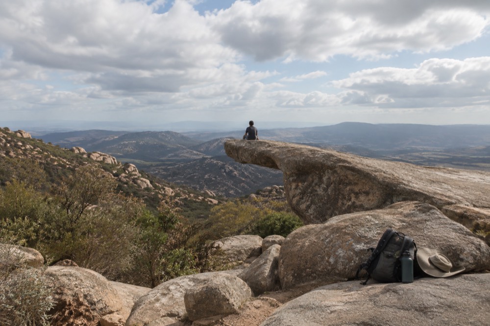
Potato Chip Rock is a remarkably thin, flat slab of granite that juts horizontally off a boulder near the summit of Mount Woodson, a peak east of Poway in inland San Diego County. Seen from the side it resembles a potato chip: flat, slightly warped, and cantilevered over open air. It does not snap, which is exactly why thousands of climbers queue every year to walk out onto it and take the photo that makes them appear to hover.
It is the most recognizable rock formation in the county's day-hiking scene.
The rock earned its name honestly. The slab is only a few feet wide at its usable end and looks, from the right angle, like it should break off under a person's weight. The drop below is real and substantial, though the slab itself is solid and has carried a steady stream of visitors for years without incident when treated with basic care.
What surprises first-time visitors is the setting. Mount Woodson is not a remote wilderness peak. It sits between the suburban communities of Poway and Ramona, close enough to Highway 67 that traffic noise follows you up the lower slopes, and its summit ridge is crowned with the towers and dishes of a communications complex. The hike is a genuine climb with real views, but it is a suburban mountain in the way that only Southern California produces: trailhead to taco shop in fifteen minutes.
The photo is the point for most people, and the trail has become famous entirely because of it. Before social media, Mount Woodson was a local fitness walk. Today, on a clear weekend morning, the line to stand on the slab can stretch back along the ridge, a queue of people in hiking shoes waiting their turn to lie flat on a rock and grin. If you come for the summit and the views rather than the photo, the crowd is part of the scenery; if you come for the photo, the crowd is the logistical problem to plan around.
For the full rundown of how this peak fits into the county's wider trail network, our Potato Chip Rock guide covers the same ground in more depth, and hiking in San Diego rounds up the other trails worth your mornings.
How Do You Actually Get to Potato Chip Rock?
There are two practical ways in. The first starts at Lake Poway, where you walk the short loop around the lake and then climb the Mount Woodson Trail from the south, a longer, steadier approach through more varied terrain. The second starts at a small trailhead on the north side off Highway 67 near Ramona, which puts you on the summit ridge sooner with less total climbing. Both routes converge on the same rocky path along the ridge.
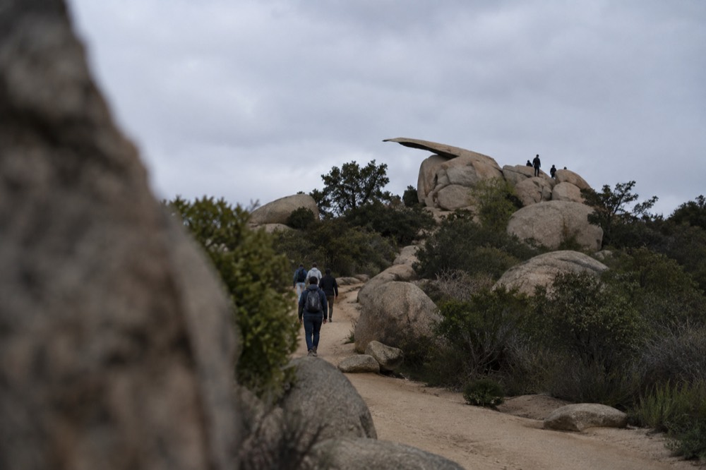
The Lake Poway side is the classic approach and the one most descriptions assume. You park at the lake, walk the flat path around the water's edge, and then begin the climb in earnest where the Mount Woodson Trail leaves the shoreline. The lower section is the steepest sustained pitch of the whole route, and it hands you most of the day's elevation gain early, which is either a mercy or a punishment depending on how you feel about stairs. The reward is that the upper ridge section, where the famous boulders sit, arrives as a relatively gentle walk with the views already banked.
The Highway 67 side is the locals' shortcut. The trailhead is a small dirt pullout on the east side of the highway, unmarked in any formal way and easy to miss, and the trail from it climbs to the ridge more directly. The trade-off is honest: less total walking and less climbing, but a less interesting walk, a shorter morning, and a trailhead with very limited parking that fills before sunrise on popular days. If your entire goal is the photo in the best light, this side wins. If you want the hike to feel like a hike, come from the lake.
| Approach | Trailhead | Character | Best for |
|---|---|---|---|
| Lake Poway side | Lake Poway recreation area, south of the peak | Longer, steadier, lake walk first, then a stiff lower climb then gentler ridge | A full morning out, first-timers, anyone who wants the complete route |
| Highway 67 side | Small pullout on the highway east of the peak, near Ramona | Shorter and steeper to the ridge, exposed, minimal facilities | Sunrise photographers, repeat visitors, tight schedules |
Two practical warnings. First, the pullout on the highway side is genuinely small, and on weekends cars spill onto the shoulder; arriving in the dark is normal and a headlamp is standard equipment. Second, the lake side sits inside a city recreation area with its own rules, hours and parking arrangements, so check the posted signs at the entrance rather than assuming anything. We do not publish parking rates for any San Diego site, and that policy applies here too: what is free, what is paid, and when enforcement starts changes often enough that the sign at the gate is the only honest source.
The rock sits close to the summit ridge but not at the very top, and the final approach is a short, hands-on scramble over granite. Most reasonably fit adults manage it without gear. Small children and anyone uncomfortable on rock should stop below and enjoy the slab from a distance, because the queue forms right at the scramble and there is no railing, no shade and no water anywhere past the trailheads.
If Mount Woodson is one stop on a bigger San Diego plan, it pairs naturally with the attractions that fill the rest of a week, and the picks above are the tickets that most visitors bundle around a hiking day.
How Hard Is the Hike, Really?
The hike to Potato Chip Rock is moderately strenuous but technically easy: a well-worn, well-marked trail the whole way, with one short scramble near the rock and no exposure anywhere else. The difficulty is almost entirely the sun. The mountain is exposed chaparral from bottom to top, with essentially no shade, no water and no facilities beyond the trailheads, so on a warm afternoon the climb becomes a heat problem rather than a leg problem.
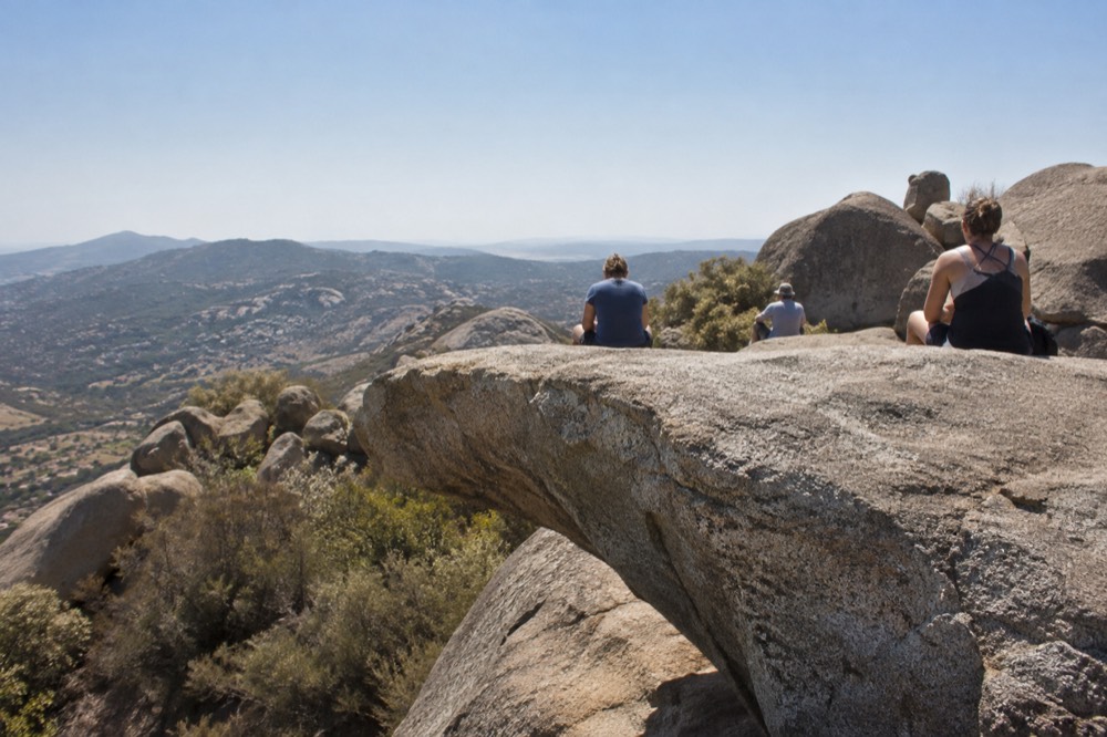
Treat it as a sun hike and everything else falls into place. That means starting early, carrying more water than feels reasonable, and accepting that a hat and sunscreen do more for your success rate than any amount of trail fitness. The trail surface itself is good: packed dirt and decomposed granite with some rocky steps on the steeper sections, runnable in both directions for anyone so inclined. Mount Woodson is in fact one of the county's most popular fitness mountains, and on any weekday morning you will share it with trail runners doing repeats.
The scramble to the slab is the only moment that asks anything of your hands. It is a few moves over solid granite with decent holds, and there is usually a queue of people above and below you offering commentary. The slab itself is flat and grippy when dry. The genuine hazards are the ordinary ones: the rock gets slippery with any moisture, the drop beneath the outer edge is serious, and wind gusts on the ridge can be stronger than the valley suggests. Nobody should be on the slab in high wind, and nobody should be backing up for a photo without looking behind them first, because the ridge drops away on both sides of the boulder.
Fitness-wise, the honest summary is this. If you walk or hike a few times a month, you will finish this comfortably at an early-morning pace. If you do not, start even earlier, take the lake side's gentler ridge, and turn it into an out-and-back that reaches the rock before the heat builds. The trail is wide enough to pass and be passed, and turning around early is a completely normal thing to do here; the views from the lower slopes are already good.
One more planning note: because the mountain sits inland, its weather is not the coast's weather. The marine layer that greys the beaches in May and June often stops short of Poway, so a grey morning in La Jolla can be a bright one on Mount Woodson, and a cool one downtown can be a hot one on the trail. Check the forecast for the inland communities, not for the coast, when you pick your start time.
When Is the Best Time of Year to Hike It?
Any month works, because San Diego's climate is forgiving year round, but the sweet spots are spring and late fall, when the air is cool, the chaparral is greenest and the trail is at its most beautiful. Summer is entirely doable if you start before dawn, and winter is the most comfortable climbing weather of all. The one stretch that needs real respect is late summer, when inland temperatures run well above the coastal figures and the exposed trail amplifies whatever the day is doing.
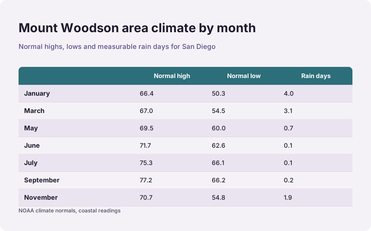
The climate normals tell the story better than folklore does. San Diego's warm months are August and September, not July: the normal high at the airport is 77.3 in August and 77.2 in September against 75.3 in July, per the NOAA climate normals. Those are coastal readings; Mount Woodson sits inland, where the marine layer's moderating hand is weaker and the afternoon sun is stronger.
| Month | Normal high | Normal low | Measurable rain days |
|---|---|---|---|
| January | 66.4 | 50.3 | 4.0 |
| March | 67.0 | 54.5 | 3.1 |
| May | 69.5 | 60.0 | 0.7 |
| June | 71.7 | 62.6 | 0.1 |
| July | 75.3 | 66.1 | 0.1 |
| September | 77.2 | 66.2 | 0.2 |
| November | 70.7 | 54.8 | 1.9 |
Two counterintuitive readings sit in that table. June's normal high, 71.7, is lower than October's 74.6, which is the marine layer, the grey coastal overcast locals call May Gray and June Gloom, showing up inside the 30-year numbers themselves. And September is statistically one of the warmest months of the year, not the tail of summer, so a September hike should be planned like an August one: pre-dawn start, done by mid-morning.
Spring is the season that changes the mountain. After the winter rains, which fall almost entirely between December and March, the chaparral greens up, wildflowers appear on the lower slopes, and the air is clear enough that the views run all the way to the ocean on a good morning. Late fall delivers the same clarity with even cooler mornings. Winter mornings can be genuinely cold on the ridge before sunrise, cold enough for gloves on the scramble, which surprises visitors who packed for the beach.
Whenever you go, the day-of formula is the same: check the inland forecast, start early enough that the summit happens before the sun is high, and be off the exposed ridge by early afternoon in the warm months. Our San Diego weather and best time to visit guide expands on the whole picture, and the monthly pages, like things to do in San Diego in June, help when your trip dates are already fixed.
What Should You Bring, and What Should You Leave Behind?
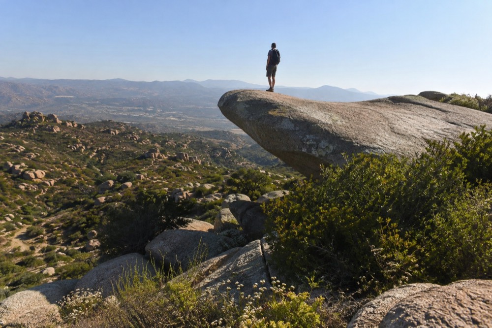
Bring more water than you think you need, sun protection, sturdy shoes with real grip, and a headlamp if you are starting before dawn. Leave behind drones, which are not welcome over the communications towers on the summit, speakers, and any assumption that you can refill a bottle on the mountain, because there is no water anywhere on the trail. The most common mistake here is not fitness, it is showing up with one small bottle and meeting the sun halfway up.
| Item | Why it earns its place |
|---|---|
| Water, more than feels reasonable | No water or fountains exist past the trailheads; the trail is fully exposed |
| Hat and sunscreen | There is no shade on the route, and the granite reflects as well as bakes |
| Grippy shoes | The slab and the scramble are safe when dry and treacherous when damp |
| Headlamp | Pre-dawn starts are standard practice, especially in the warm months |
| Layers in winter | Ridge mornings before sunrise run much colder than the coast suggests |
| Snacks | The queue at the rock can add real standing time to your summit plan |
A few things deserve a second mention. Footwear matters more here than on most hikes of this difficulty, because the payoff is standing on smooth granite. Trail runners with worn tread and the slab's morning dew are a bad combination, and the scramble's holds reward confidence that only good grip gives. If you hike in anything less than a proper sole, at least check the slab is dry before you commit.
Drones are the other one. The summit of Mount Woodson bristles with communications infrastructure, and flying near it is both disruptive to everyone else's morning and a bad idea around that equipment. The classic photo does not need a drone anyway; the slab photographs perfectly from the ridge path with nothing more than a phone, and the person waiting behind you will usually offer to take it.
Finally, leave no trace is not a slogan on this trail, it is the reason the trail still looks the way it does. The route gets heavy traffic, and everything from orange peels to tissue ends up staying visible for months in the chaparral. Pack out everything, stay on the established path, and give the boulders' lichen the same respect you would give the slab itself.
How Do You Get the Classic Photo Without the Wait?
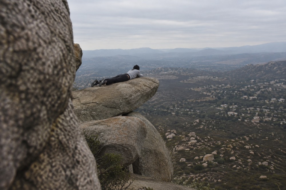
Start at sunrise on a weekday and the rock is often free; arrive mid-morning on a weekend and you will join a line. The photo itself is simple: the subject walks to the outer end of the slab, the photographer drops low on the ridge path and shoots upward and outward, so the rock's thin profile and the drop below fill the frame. The trick is entirely in the angle and the light.
Morning light hits the slab broadside, which is why almost every famous shot from here was taken before ten.
The etiquette of the queue is worth spelling out, because it is self-organized and works well when everyone plays along. One group on the slab at a time, a couple of minutes each, cameras ready before your turn rather than during it, and nobody standing on the slab while they decide what pose to try. On a busy morning a single person fiddling with settings can hold up thirty people. If you want a long, unhurried shoot, weekday sunrise is the only realistic window.
The poses are a genre unto themselves. The flat lie, arms at the sides, is the classic and reads cleanest from below. The sit-and-dangle makes the drop look deeper than it is. The jump shot is popular and, on a calm day, fine; in wind it is not, and the ridge does get wind. What every version shares is the low camera position: shoot from the path below the boulder and the slab's underside shows, which is the whole illusion. Shoot from standing height and the rock looks like what it is, a short platform a few feet above the hillside.
Respect the edge. The slab is solid, but the ground around it is not a studio: the ridge drops on both sides, the rock is polished by traffic, and the queue means people are standing around on uneven granite while distracted. This is the moment for ordinary caution, not heroics, and every photo anyone actually wants can be taken with both feet planted.
Where Else Should You Hike Near San Diego?
The county's other headline trails split into three groups: coastal walks like the paths at Torrey Pines and Sunset Cliffs, canyon and urban-edge routes closer to town, and bigger inland and desert climbs like the ones around Julian and Anza-Borrego for hikers who found Mount Woodson comfortable. Potato Chip Rock is a fair midpoint in that ladder: harder than any beach walk, easier than the desert's long routes, and the natural stepping stone toward the county's more serious mountains.
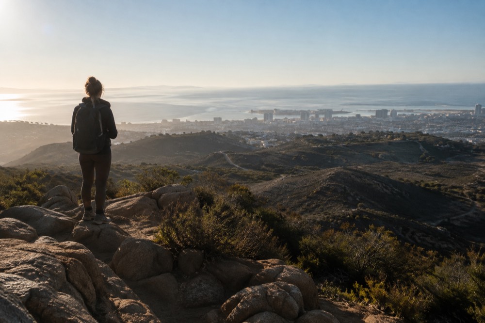
The coastal pair first. Torrey Pines State Natural Reserve offers short trails over a rare pine-covered bluff with ocean views, and Sunset Cliffs Natural Park delivers an easy shoreline walk above sea caves. Neither is a workout in Mount Woodson's sense, but both are beautiful in the golden hour in a way an inland peak cannot match, and both pair well with a swim.
For something that keeps the climbing but changes the scenery, the county's east holds the real escalation. Julian and Anza-Borrego sit about an hour and more from the city, and both are destination hikes rather than before-work ones, which is why they suit a day with nothing else planned. If Mount Woodson left you wanting longer ridgelines and nobody in front of you, that is the direction to look, and our hidden gems in San Diego guide keeps a running list of the quieter options.
If your trip is short and the hike eats a whole morning, a guided highlights tour is the efficient way to see Coronado, the waterfront and the beaches you did not have time to walk. It is a different kind of day out, but it solves the same problem: limited hours, and a lot of San Diego.
How Do You Build a Full Trip Around the Hike?
Treat Mount Woodson as a half-day anchor and spend the afternoon recovering on the coast. A pattern that works well: hike at dawn, breakfast in Poway or back toward the coast, then an afternoon at the Zoo, the USS Midway Museum or a harbor cruise, all of which are flat, shaded or seated, exactly what your legs will want. With three or more paid attractions on your list, a bundled pass usually beats buying individual tickets.
The pass logic is simple. The San Diego CityPASS packages SeaWorld or LEGOLAND together with a choice of three further attractions from a list that includes the Zoo or Safari Park, the USS Midway Museum, a harbor cruise and the Maritime Museum, saving up to 48 percent against individual gate prices, valid over nine consecutive days from first use. A hiking morning slots perfectly into that structure: the pass covers the slow, sight-seeing half of your days, and the mornings stay free for the trail.
The Midway deserves a specific mention for hikers, oddly enough. After a morning of climbing, an aircraft carrier is the ideal afternoon: you walk its flight deck at your own pace, the exhibits are indoors when you want them to be, and the views over the bay from the deck are the county's best seated scenery. It sits right on the Embarcadero, so it pairs naturally with a harbor cruise or a wander through Seaport Village afterward.
Families get a different arithmetic. LEGOLAND California, up in Carlsbad, is a full day on its own and does not combine with a dawn hike unless everyone involved is very committed, so most families put the two on separate days and use the drive between them for a beach stop. The kids' ticket offers change seasonally, so read the live listing rather than any summary, ours included.

For the practical spine of the trip, two of our planning guides carry most of the weight: getting around San Diego for the trolley, bus and rental car questions, and parking in San Diego for the meter and lot rules that catch visitors out downtown. The short version for this article: Mount Woodson needs a car or a very patient rideshare plan, and the transit fare chart that matters for the rest of your trip is the MTS one, where a one-way ride is $2.50 and fare capping through the PRONTO system means there is no reason to buy a day pass up front.
And if the trip is still shapeless, start from the top: Things to Do in San Diego is our master list, and the one day in San Diego and first time in San Diego guides turn it into an order that makes sense on the ground.
Common Questions About Potato Chip Rock
Is Potato Chip Rock dangerous?
The slab itself is solid and has carried a steady stream of visitors for years. The genuine risks are ordinary ones: the drop beneath the outer edge is serious, the granite is slippery when damp, and the ridge catches wind. Go when the rock is dry, skip it in high wind, and treat the queue area with the same caution as the slab.
Do you need a permit or reservation to hike Mount Woodson?
No. The trail is open to the public with no permit, no reservation and no quota. The only capacity limit is parking, and at the smaller Highway 67 trailhead that limit is real on weekends, which is the practical reason most people start before sunrise.
How long does the Potato Chip Rock hike take?
It depends on your start point and pace. The lake side makes a full morning of it at a comfortable pace, while the highway side is a shorter, faster outing. Either way, budget extra time for the photo queue at the slab, which on a weekend morning can add a meaningful wait to your summit turn-around.
Can beginners do the Potato Chip Rock hike?
Yes, with honest timing. The trail is well graded and well marked, and the only technical moment is a short scramble near the rock. Beginners should start early, take the lake side, carry plenty of water, and treat turning around early as a normal option rather than a failure.
What is the best time of day for the Potato Chip Rock photo?
Morning, and early morning at that. The light hits the slab broadside before mid-morning, temperatures stay sane, and the queue is shortest at sunrise on a weekday. Afternoon light flattens the rock's profile, and by then the line and the heat have usually both arrived.
Where is Potato Chip Rock exactly?
On the summit ridge of Mount Woodson, east of Poway and west of Ramona in inland San Diego County, about half an hour's drive from downtown San Diego. It is reached on foot only, from either the Lake Poway recreation area or the small trailhead off Highway 67.